A showcase of my work, experiments, and ongoing projects.
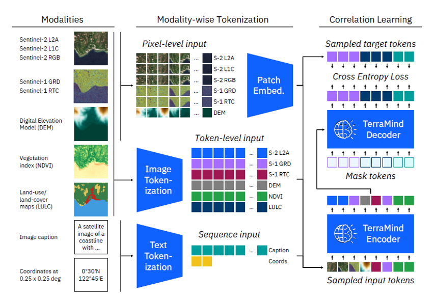
Comprehensive research into AI-powered Earth observation and satellite imagery analysis, focusing on TerraMind GFM and AlphaEarth technologies. This master's thesis explores cutting-edge developments in geospatial foundation models, multimodal data processing, and advanced machine learning architectures for satellite imagery interpretation.
A comprehensive professional Python library for PlanetScope satellite imagery discovery, analysis, and processing. Designed for researchers, GIS analysts, and Earth observation professionals seeking advanced satellite data workflows.
A dynamic portfolio website built with Nuxt.js and Vue.js, featuring both public project showcase and a secure admin dashboard. Integrates Supabase for authentication and database functionality, enabling content management without redeployment. Includes responsive design with Tailwind CSS and GDPR-compliant analytics via GoatCounter.
Developed CNN-based models for Blood Cell Classification and Mars Terrain Segmentation. Leveraged TensorFlow for efficient model training and deployment, achieving high accuracy in classification and segmentation tasks.
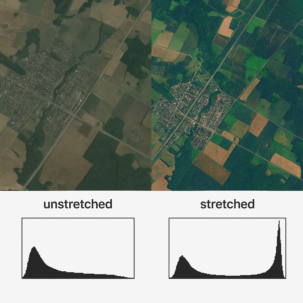
A Python library for geospatial raster enhancement through histogram manipulation. Offers stretching, matching, and equalization modules to improve image contrast and normalize datasets. Built with Rasterio and NumPy, it preserves spatial integrity while providing visualization tools for comparing original and processed imagery, essential for remote sensing applications.
Fresh Flow is a Flutter-based mobile application leveraging Firebase for real-time database management and Google ML Kit for barcode and text recognition. It enables efficient grocery inventory tracking, expiry date monitoring, and dynamic shopping list generation. Core functionalities include authentication, CRUD operations, cloud synchronization, push notifications, and modular UI customization.
In our project, we conducted a comprehensive analysis focusing on landslide susceptibility in Northern Italy. Our mission was to enhance terrain stability awareness and improve risk management through detailed mapping.
Developed Python-based risk analysis software for landslide monitoring. Utilized AWS relational database based on PostgreSQL with PostGIS extension for spatial data management and analysis.
A comprehensive web application that provides support, resources, and education to victims of domestic violence, their families, and the public. The platform serves as a safe place where individuals can access critical information, connect with support services, and engage in community discussion.
This research investigates the structural stability of high-voltage transmission tower foundations when constructed on hill slopes in the Himalayan region. Using finite element analysis, we evaluated the performance of transmission tower foundations on both plain ground and 45° inclined surfaces, identifying critical displacement patterns and stress concentrations. The study provides valuable insights for safer transmission infrastructure in mountainous terrains, especially in areas prone to earthquakes and landslides. The research was conducted at Aligarh Muslim University and culminated in a published paper in AIP Conference Proceedings.